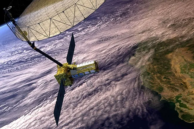
When NASA announced that it had successfully unfurled the largest antenna reflector it has ever built, the milestone was easy to miss amid the blur of space headlines. No humans were on board, no breathtaking planetary images were released. Yet, quietly orbiting Earth, a gold-tinted disk the size of a small house just opened a new window on the planet we call home.

That reflector belongs to the NASA-ISRO Synthetic Aperture Radar (NISAR) mission — a joint venture between the U.S. space agency and India’s ISRO. And though it looks like a giant umbrella, this 12-meter structure is no ordinary piece of hardware. It will allow scientists to see our planet in ways that cameras and even other radars simply cannot: through clouds, through forest canopies, across seasons, and with centimeter-level accuracy.
The implications are enormous. From tracking melting ice sheets and shifting glaciers to mapping earthquake fault lines, from monitoring wetlands and crops to forecasting disasters, the largest antenna reflector NASA has ever flown is about to become one of the most important instruments in climate and Earth system science.
Why Build Such a Giant Antenna?
At first glance, the idea of launching a 12-meter-wide dish into orbit might seem like overkill. After all, Earth is already covered in satellites. Dozens of optical imagers, weather sensors, and even older radar instruments already peer at the planet daily.
The answer lies in the unique physics of synthetic aperture radar (SAR).
- Optical satellites are like cameras: they depend on reflected sunlight. They can’t see at night or through thick clouds.
- Traditional radar satellites send radio waves and measure the echoes, which lets them see day or night and penetrate clouds. But their resolution depends heavily on antenna size: bigger dish, sharper images.
That’s where synthetic aperture radar comes in. Instead of relying on just the physical size of its antenna, SAR uses the satellite’s motion along its orbit to “synthesize” a much larger aperture. This allows it to achieve extremely fine resolution — often down to meters or even centimeters — even from hundreds of kilometers away.
The catch: to make SAR work across different frequencies and surfaces — ice, forests, mountains — you still need a large reflector to catch weak return signals. That’s why the NISAR mission’s 12-meter antenna, weighing only 64 kilograms thanks to its mesh-and-strut design, is such a breakthrough. Without it, the radar beams from orbit would simply scatter too faintly to reconstruct useful images at scale.
Two Radars, One Planet
Another reason this antenna matters is because NISAR carries two different radar systems simultaneously:
- L-band radar (longer wavelength, ~24 cm): penetrates vegetation, soil, and even snow. It’s ideal for measuring forests, subsurface geology, and subtle ground deformations.
- S-band radar (shorter wavelength, ~12 cm): more sensitive to finer features like snow moisture and smaller vegetation structures.
Mounted on the same spacecraft, both beams will bounce off Earth and back to the massive reflector. That golden dish then focuses the signals onto the radar sensors, enabling a dual-frequency, complementary view of Earth’s surface changes.
It’s the first time NASA has flown a dual-band SAR system in one mission.
Physics in Action: From Faults to Forests
What can such a radar actually “see”? Here’s where the physics gets practical.
- Ground Deformation (Earthquakes & Volcanoes): SAR is exquisitely sensitive to small changes in surface elevation. Using a method called InSAR (Interferometric SAR), scientists can detect ground shifts as small as a few centimeters between satellite passes. This is vital for tracking earthquake faults, volcano inflation, and even landslide risk zones.
- Ice and Glaciers: Radar waves bounce differently off ice than off bare ground. With L-band, NISAR will track how glaciers and ice sheets move and thin. This helps quantify sea-level rise contributions from Greenland and Antarctica with new precision.
- Forests and Carbon: Vegetation scatters radar signals depending on density and structure. That makes SAR ideal for estimating forest biomass — a key factor in understanding the global carbon cycle and climate change.
- Wetlands and Agriculture: Radar penetrates vegetation canopies, revealing water beneath. NISAR will track the health of wetlands, rice paddies, and crop cycles, offering crucial data for food security and flood forecasting.
- Infrastructure Monitoring: Bridges, dams, and cities deform subtly under stress. By revisiting the same area every 12 days, NISAR can detect tiny subsidence or strain that precedes disasters.
Why the Reflector Is the Star
You could think of the reflector as the ear trumpet of the mission. Without it, the faint radar echoes would be too weak to resolve at global scales. With it, NISAR can cover the entire planet with high-resolution swaths up to 240 kilometers wide — far larger than most existing SAR missions.
Its construction is an engineering marvel in itself:
- Structure: A lightweight cylindrical frame of 123 struts.
- Surface: Gold-plated wire mesh that reflects radar frequencies but weighs a fraction of a solid dish.
- Deployment: It rode to space folded up like an umbrella, then extended on a nine-meter boom before locking into place.
That blend of delicacy and strength means NASA can now fly an antenna three times larger than previous radar missions without breaking the spacecraft’s weight budget.
Comparisons: How Big a Leap Is This?
To put this in perspective:
- ESA’s Sentinel-1 SAR missions (operated by Europe) use a C-band radar with a much smaller array (12 m by 1 m panel).
- Japan’s ALOS-2 carries an L-band radar but with narrower swath coverage.
- NASA’s older radar shuttle missions in the 1990s and 2000s used large deployable antennas, but none approached the scale or dual-frequency capability of NISAR.
The new reflector doesn’t just make NISAR the largest civilian radar eye in orbit — it also makes it the most versatile.
The Global Payoff: Climate, Disasters, and Beyond
Where will this data matter most? Three areas stand out.
1. Climate Change Tracking
- Ice sheets and glaciers: Mapping melt rates will sharpen sea-level rise predictions.
- Forests: Biomass data feeds directly into climate models and carbon accounting frameworks like REDD+.
- Wetlands: Monitoring how wetlands expand or dry up reveals climate-driven hydrological shifts.
2. Disaster Preparedness
- Earthquakes: Fault stress and post-quake shifts mapped in near-real time.
- Volcanoes: Inflation and subsidence patterns spotted before eruptions.
- Landslides & Floods: Identified early, aiding evacuation and relief.
3. Infrastructure & Agriculture
- Urban monitoring: Subsidence in megacities like Jakarta or Mexico City.
- Dams & levees: Early warning of strain or cracks.
- Crop cycles: Key for food security planning in Asia and Africa.
In short, the reflector turns NISAR into a planetary-scale stethoscope — constantly “listening” to Earth’s surface for signs of change.
A U.S.–India Partnership With Global Stakes
NISAR is not just about the hardware. It represents one of the deepest scientific collaborations between NASA and ISRO.
- India provided the S-band radar and will operate the mission from its facilities.
- NASA contributed the L-band radar, the giant reflector, and the satellite bus.
- Data will be openly shared worldwide, breaking down silos between national space programs.
That openness is critical. Climate change, tectonic hazards, and food security don’t stop at borders. By pooling resources, NASA and ISRO are building a dataset that will benefit not only their own nations but scientists and policymakers everywhere.
What Comes Next
With the reflector deployed, NISAR is now undergoing calibration before it begins full science operations in 2026. Once operational, it will circle the Earth every 12 days, collecting petabytes of radar data.
The mission is planned for at least three years of continuous observations, though NASA’s radar missions have historically lasted much longer. If NISAR follows that trend, it could provide a decade of uninterrupted global monitoring — a treasure trove for science and policy alike.
The Quiet Revolution in Watching Earth
It’s easy to overlook a satellite that doesn’t beam down Instagram-worthy photos. But in many ways, NISAR’s giant golden ear may be more consequential than any optical telescope. By mapping the invisible — stress building underground, water pooling beneath vegetation, ice creeping toward the sea — it delivers the kind of knowledge that lets societies prepare, adapt, and survive.
NASA called the reflector “a key role” in the mission. That’s an understatement. It’s the difference between vague awareness and centimeter-level clarity. In an era of planetary crisis, that clarity is everything.


